Join us for a happy hour celebrating all of the great open data we have available about mobility in New York City! This happy hour is hosted by Young Professionals in Transportation, the Metropolitan Transportation Authority, and the NYC Department of Transportation. You do not need to be a member of any of these organizations to join, all are welcome!

This happy hour is taking place at Amity Hall Downtown, 80 W 3rd St, Manhattan.

Before the happy hour, join the MTA and DOT for a virtual event about mobility data.

The Marron Institute of Urban Management will host an afternoon of presentations featuring research from its Transportation and Land Use, Civic Analytics, and Health, Environment and Policy programs, alongside NYU Grossman School of Medicine’s City Health Dashboard and Congressional District Health Dashboard. The event will highlight how these teams apply open data to advance research and policy in transportation, urban systems and public health.

Presenters will discuss how they compile, integrate, and analyze complex datasets to inform urban policy and decision-making. They will also share approaches for making data accessible to broader audiences, including strategies for transparency, effective communication, and open access to data and research findings.

This event is intended for anyone interested in how data-driven research can strengthen policymaking, expand access to information, and promote more transparent, equitable, and effective public sector decisions.

Light refreshments will be provided.

Schedule:
1:00 – 1:05  Introduction
1:05 – 1:45  Transportation and Land Use Program (Marron Institute): Elif Ensari, Research Scholar and Program Deputy Director, Franklin Tang, Assistant Research Scholar.
1:45 – 2:25  Civic Analytics Program (Marron Institute): Bartosz Bonczak, Research Scientist and Lab Manager, Callie Clark, Doctoral Researcher.
Break
2:40 – 3:20  Health, Environment, and Policy Program (Marron Institute): Noussair Lazrak, Research Scientist.
3:20 – 4:00  City Health Dashboard and the Congressional District Health Dashboard (NYU Grossman School of Medicine): Ben R. Spoer, Program Director.

New York City’s food supply chain relies on a distribution system dependent on diesel trucks, creating compounding environmental and economic burdens in the South Bronx. This session, hosted by independent researcher Dan DeWitz, examines Hunts Point—home to the city’s largest wholesale food distribution hub—through the intersecting lenses of air quality, poverty, and climate risk. Participants will learn to critically evaluate environmental data, test the statistical significance of neighborhood-level air quality differences, and understand the limitations of relying on existing monitoring systems as “ground truth.”

Looking forward, the session explores policy alternatives to the current model. By mapping Metro-North and LIRR rail lines alongside regional farmland and underserved communities, we will examine the untapped potential of existing transit infrastructure to reduce diesel emissions and improve food access. With portions of Hunts Point projected to flood under future climate scenarios, change is not just desirable—it is inevitable.

This event is ideal for anyone interested in environmental justice, urban planning, transportation policy, food systems, or applied data science. Whether you are a community advocate, policymaker, student, or curious New Yorker, you will leave with a deeper understanding of the data behind urban inequality and practical frameworks for solutions.

While initiatives like Mapping for Equity document what exists (or doesn’t exist) in public spaces, these gaps must be communicated or demonstrated so that community demand for invisible, unbuilt amenities can be recorded. Open Streetmap has a few ways to note desire or proposed amenities, but civic media can also help. inCitu, a NYC-based augmented reality company, proposes AR as a tool to bridge this gap: by combining data from projects like Mapping for Equity and Spatial Equity NYC with augmented reality (AR) visualization, communities can create compelling artifacts, like AR videos and mockups, that advocate for repair, preservation, and creation of public space infrastructure where it’s needed most. This session will present a sample workflow, from scanning an existing amenity to creating an AR video of it in a new location, and will be followed by open discussion on civic design considerations how this method might contribute to existing efforts.

Using data insights to make decisions is what every organization seeks to do, but there are many reasons why this doesn’t happen in practice: data is hard to find, it is siloed and inaccessible, it is undocumented and difficult to understand, it is too large or complex for the skills and tools available. All these problems existed at Metropolitan Transportation Authority

(MTA) and were the motivation for the recent establishment of a central data team, which has the goal of facilitating analytical work for teams all across the company. Standing up such a team is challenging, especially for public sector agencies with many internal and external stakeholders, legacy systems and limited resources. In this talk, Andy Kuziemko, who leads the Data & Analytics team at the MTA, will describe the progress to date at the agency, lessons learned along the way, and the remaining challenges the agency faces.

Join the NYC Council Data Team for an inside look at how open and administrative data drive policymaking at the Council. In this interactive exhibition, Senior Data Scientist Reese Hirota and Data Scientists Taylor Francisco, Danylo Orlov, and Erik Brown will showcase four tools designed for evidence-based decision-making. From tracking citywide trends in domestic violence and evaluating Vision Zero safety interventions to mapping public restroom equity and optimizing fieldwork with StoopLoops, attendees will see firsthand how raw datasets become transparent tools for the public.

This session is ideal for civic tech enthusiasts, policy researchers, and engaged New Yorkers eager to understand the “how” behind city oversight. The event will feature 40 minutes of guided walkthroughs focused on the design and impact of these platforms, followed by an interactive Q&A. During the session, participants will have the opportunity to explore the dashboards themselves, engaging directly with the team to uncover data-driven insights relevant to their own communities.

By bridging the gap between raw information and legislative action, these projects demonstrate that open data is the essential foundation for a more equitable NYC. Attendees will leave with a clear understanding of how the Council identifies citywide needs, tracks outcomes, and makes the policymaking process more transparent and data-informed. Registration closes at 2 p.m.

In this training, data scientists on the Metropolitan Transportation Authority’s (MTA) Data & Analytics team will teach attendees how to query big bus data off of the Socrata-powered open data portals using Socrata Query Language (SoQL). The first half of the session will be done entirely using in-browser tools, no special software required!

For the second half of the session, we’ll dive deeper into how to join bus route segment speed data to geospatial shapes in order to create map-based visuals. Python experience recommended to those who want to follow along, though all are welcome to listen in and learn! A URL to a GitHub repository will be added to this event page at a later date.

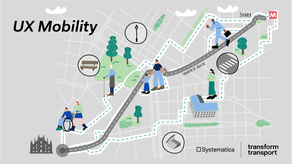
Join this hands-on walking workshop that turns NYC streets into a living lab! Together, we will test a custom, data-enabled pedestrian routing system built from publicly available layers such as sidewalks, pedestrian ramps, traffic volumes, thermal comfort, tree canopy, and other walkability indicators. The goal is to see what these datasets capture about moving through the city and what they miss. This approach, called UX Mobility routing, was developed and tested in Milan and is now being applied to a selected NYC area to spark new insights on inclusive, experience-aware mobility.

Led by moderators from Systematica and Transform Transport, participants will follow the predefined route in small groups and use a simple guided toolkit to document the sensory, cognitive, emotional, and physical side of the walk. We will consider factors like noise, crowding, comfort, clarity, and perceived safety, then compare lived experience with what the mapped layers suggest. The session concludes with a collective data–experience gap map and a set of takeaways on how NYC Open Data could better reflect real walkability through new layers, combinations of data, or proxy indicators such as using traffic patterns to estimate noise. Open to everyone, with no technical background needed, all mobility levels welcome, and materials provided.

The meeting point for this event will be in front of 5 MetroTech Center in Downtown Brooklyn.

NYC School of Data is BetaNYC’s community conference that demystifies the policies and practices around open data, technology, and service design. This year’s conference helps conclude NYC Open Data Week and features 40+ sessions organized by NYC’s civic technology, data, and design community! Our conversations and workshops will feed your mind and inspire you to improve your neighborhood.

To attend, you need to purchase tickets. The venue is accessible, and the content is all-ages friendly! If you have accessibility questions or needs, please email the BetaNYC team at [email protected].

Thank you to Reinvent Albany for their support as Lead Partner and helping cover conference costs to make it possible to meet in 2026. Additional sponsors include HaydenAI, SVA Masters in Data Visualization and Communication, Nava, The Center for Urban Science + Progress (CUSP) at NYU Tandon. and Cyvl

If you can’t join us in person, tune into the main stage live stream provided by the Internet Society New York Chapter. Follow the conversation #NYCSoData on Bluesky.

Purchase your tickets here.